Southwark and the Mayflower Part 5: Borough

The area around Borough High Street was the focus of the Pilgrim church in London. The first Brownist church met near Long Lane to the east of the High Street, and there is evidence that the second church, administered by Henry Jacob (1616-22), was in the parishes of St Olave and St Saviour around London Bridge. The third church, of Henry Jessey, seems to have formed around St George the Martyr and in Bankside, to the west. The Borough was also the site of prisons where pilgrims were incarcerated in response to their demands for freedom of speech and assembly.

Southwark Cathedral

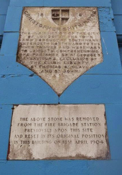
The cathedral’s origins are in the Priory Church of St Mary Overie, built in 862 AD. The priory became the parish church of St Saviour, and in 1905 was designated a cathedral. The Pilgrim church of Henry Jacob had members who worshipped at St Saviour (as well as in their gathered church) and in 1604, when Jacob was in prison in the Clink, a Mr Philips bravely manifested sympathy with his views in the sermons he preached here. In the north transept is the Harvard chapel, dedicated to John Harvard the Puritan, pilgrim and benefactor of Harvard University. Delftware pottery dating back to 1612 has been found In the Chapter House, providing a connection to the Dutch puritan community. The new North Entrance doors, by Wendy Ramshaw were designed around the theme of pilgrimage.

P 277 Southwark Cathedral 1813.jpg

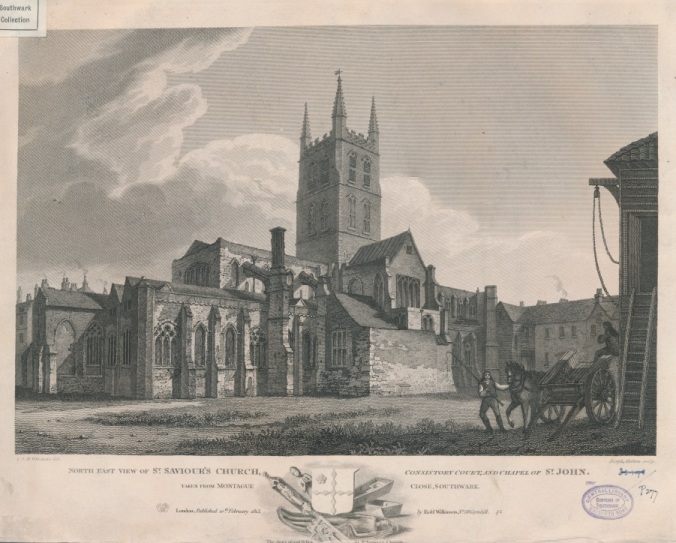
Southwark Cathedral in 1813, when it was still St Saviour’s Church

The George Inn

This Borough High Street pub was in existence at the time of the Pilgrims and may have been used by them, (there was no temperance movement in the 17th Century). It is the only galleried pub left in London and is mentioned in the writings of Charles Dickens. Nearby are the sites of The White Hart Inn, (mentioned by both Shakespeare and Dickens), The Tabard Inn, (later the Talbot Inn) where Chaucer’s pilgrims met before setting out, and the Queen’s Head Inn, owned by the family of John Harvard.

George Inn 1889 p18794

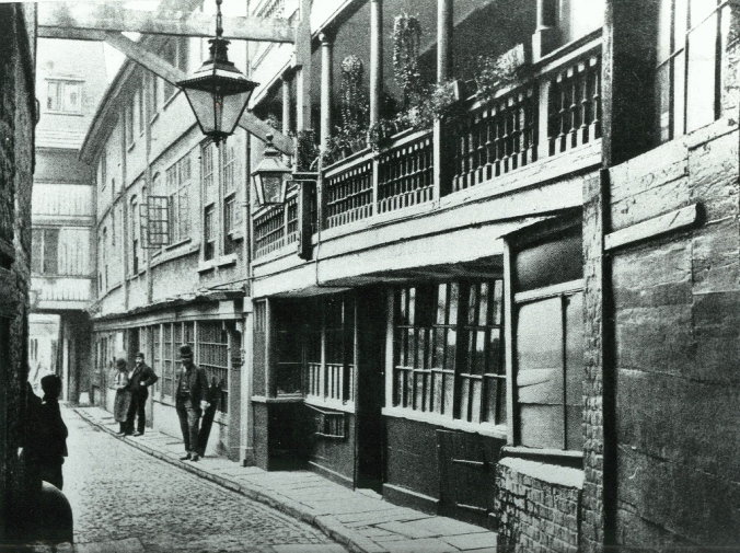
The George Inn in 1889
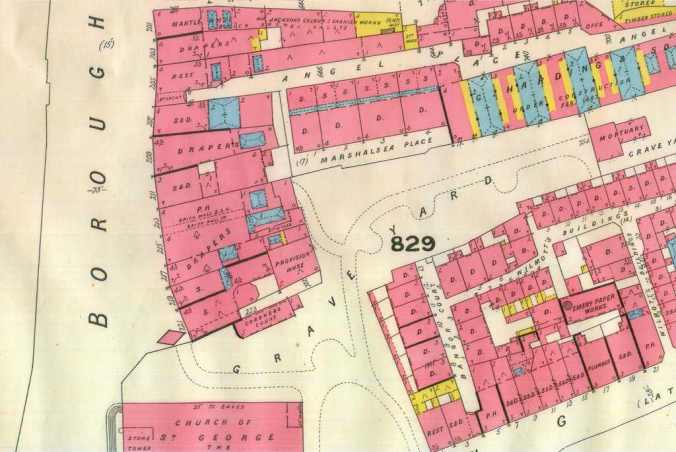
Angel Place

This alleyway, connecting Borough High Street to Tennis Street, was the address of the King’s Bench Prison, from where John Penry sent a letter in 1593, advising his followers to consider emigration. It also contains the remains of the second Marshalsea Prison, referred to in Charles Dickens’ Little Dorrit. The original Marshalsea Prison, where members of the Pilgrim Church were held stood 130 yards north of this point from 1373 until 1811. Adjacent to the alley is the John Harvard Library (also containing Southwark’s Local History Library and Archives) which bears a plaque in Harvard’s memory.

St George the Martyr Church and St George’s Garden

On the other side of Angel Place is the former churchyard of St George the Martyr Church, bounded by the Marshalsea Prison Wall. Henry Jessey was rector here, and in 1637 became pastor of the Pilgrims’ ‘gathered church,’ preaching at St George’s on Sunday morning and at the gathered church in the evening. Jessey is most well-known for his work with the Jewish community. An enthusiastic student of Hebrew, he used to correspond with Rabbi Mannaseh ben Israel in Amsterdam. Jessey successfully campaigned for the readmission of Jews to Britain and for the foundation of a college of Jewish studies.

Marshalsea Goad plan

Plan of the area around St George the Martyr Church from Goad insurance map, 1887


Southwark and the Mayflower Part 4: Old Kent Road

The Old Kent Road has been an important thoroughfare since Roman times, connecting London to Canterbury and Dover. This short tour from Burgess Park towards Elephant and Castle takes in some Mayflower connections and a link to some much earlier pilgrims.

St Thomas-A-Watering, Old Kent Road

St Thomas-a-Watering is a very significant site in Southwark’s history, but it is easily overlooked amid the hustle and bustle of the junction of Albany Road with Old Kent Road. It was at this spot that pilgrims travelling from St Mary Overie (a predecessor of Southwark Cathedral) to the shrine of Thomas a Becket in Canterbury made their first stop to water their horses and take refreshment. The pond in Burgess Park was said to be where Chaucer’s Pilgrims took their horses for a drink.

St Thomas-A-Watering represented the southern boundary of the parish of St George the Martyr and as such also represented the limit of the City of London’s jurisdiction in Surrey. Once a year, the Lord Mayor and Sheriffs of the City of London rode in procession, all wearing scarlet gowns, over London Bridge to open Southwark Fair and to inspect the City’s boundaries at St Thomas a Watering. There is a plaque inlaid into the nearby former fire station that marks this spot.

The Mayflower connection comes from protestant martyr John Penry, who was executed here on 29th May 1593. His body was hung on a gibbet on the Old Kent Road. Some regard Penry, a Welshman, as the true founder of the Brownists, not Robert Browne. Penry sent a letter from the King’s Bench Prison, dated 24th April 1593, advising his followers to consider emigration. This is the start of the Pilgrims’ journey, first to Holland and then to America.

St Thomas a Watering city stone.jpg

Plaque marking the southern limit of the City of London’s jurisdiction

Bricklayers Arms Roundabout, New Kent Road

The Pilgrim Fathers Memorial Church, which originally stood at Deadman’s Place in Bankside was relocated in 1864 to Buckenham Square, close to this site. Its gardens were named the Mayflower Gardens and contained a memorial to the ship; a sundial set on a large stone with a panel depicting the Mayflower on one side. When the Bricklayers Arms flyover was built in the 1970s there was much disruption. The Pilgrim church moved to Great Dover Street but Mayflower Gardens was left behind, complete with its monument. St Saviour’s & St Olave’s School for Girls was built close by, and the memorial is now inside.

St Mary Newington Church, Newington Butts

The original site of this church is now occupied by a park on the west side of Newington Butts. Thomas Gataker was Rector here from 1584 to 1593 before he became Rector of St Mary Rotherhithe. Later, Thomas Wadsworth was Rector, as well as being Pastor of the Pilgrim church. Nearby “Newington woodes” was recorded as the site of the arrests of some of Browne’s followers.

P00349 St Mary Newington

Next week: The Borough

Southwark and the Mayflower Part 3: Rotherhithe

We’ve already explored the history of the Mayflower in Bankside and Bermondsey, and now we’ve come to Rotherhithe, which has more visible monuments to the story than anywhere in London. This is where master mariner Christopher Jones lived and worked and where the ship was finally broken up for timbers.  

Greenland Dock

Christopher Jones, the ‘Captain / Master’ of the Mayflower lived and worked in Deptford, yet his children were baptised at the parish church of St Mary, Rotherhithe. These two apparently contradictory facts help us to pinpoint the location of his home. We can tell from a map of Rotherhithe, drawn in the 1620s that the whole peninsula fell within the parish of St Mary, right down to the Deptford border, and that the eastern shoreline was uninhabited except for the site now occupied by Greenland Dock. A community flourished there, presumably because the natural inlet or creek could be used by ships. Thus the map shows fairly conclusively that this site was the only place that Jones could have been living. It is also very likely that this is where the Mayflower was berthed since the northern shore had no inlets, only a tidal beach.

However, the Mayflower could not have embarked with its cargoes and passengers from Rotherhithe. The Port of London tightly controlled all loading and unloading of cargoes. Furthermore, transporting passengers to the ship with all their possessions and cargo across the Rotherhithe Peninsula would have been very difficult. The only access from London Bridge even by 1696 was along the Redriffe Wall (which was only 10 feet wide) or along West Lane (only 9 feet wide). Historians have always been clear that the Mayflower began its famous transatlantic voyage from either Blackwall or Wapping. As Greenland Dock is nearer to Blackwall, this reinforces the majority opinion.

Christopher Jones Square, Lower Road

On the way from Greenland Dock to St Mary’s Church you might pass this garden, named after the master of the Mayflower. Lower Road contained an abundance of Nonconformist chapels, at least one of which had a connection with the Pilgrim Church.

IMG_0915.JPG

St Mary’s Rotherhithe

St Mary’s Church, St Marychurch Street

The church that stood here in 1620, when Christopher Jones and his crew worshipped inside was built in the 14th century. The building we see today replaced it in the early 18th century.

Jones is buried in the churchyard here, as are some other crew of the Mayflower. A plaque was installed inside the church in his memory in 1965 and a statue was unveiled in the churchyard in 1995.

In 2004 a blue plaque was installed on an outside wall recording the connections between the church and the Mayflower expedition, which are not limited to Jones and the crew. The Rector from 1611 to 1654 was the Puritan, Thomas Gataker. He had many Dutch contacts, including the Pastor of the Dutch church in London and visited the Netherlands in July 1620.

The Mayflower Pub, Rotherhithe Street

This pub, which stands just a few yards from St Mary’s Church very enthusiastically celebrates the Mayflower story. On the wall of the restaurant upstairs you can find a list of the Mayflower passengers. Unfortunately, it has no real connections with the Mayflower but an inn (originally known as The Shippe) has stood in the vicinity since Jones’s time.

Mayflower 1955

The Mayflower pub, c.1950

Sunbeam Weekly and the Pilgrim’s Pocket

This is a modern statue of a Puritan and a young boy surveying, ironically, the history of the USA since the Mayflower. Created by local artist Peter McLean and erected in 1991, it is a fascinating and amusing take on the Pilgrim story.

Surrey Lock, Rotherhithe Street

Rotherhithe was famous for its shipbuilding, ship-repair and ship-breaking businesses and the Mayflower was probably broken up along this stretch of the river. There was a large dry dock here by 1739-46 at the King and Queen Stairs and near what is now the Salt Quay pub was the John Beatson yard – Rotherhithe’s best known shipbreaker. In 1838 the HMS Temeraire was broken up here, and immortalised in a painting by JMW Turner. Surrey Lock, which now occupies this site, was built by the mathematical genius and engineer George Bidder.

Next week: Old Kent Road